| Type of paper: | Research paper |
| Categories: | Technology |
| Pages: | 7 |
| Wordcount: | 1842 words |
In the twenty-first century, urban areas had become the main residential areas as contrasted to earlier centuries when people used to live in rural areas and practice agriculture. Today the economy is industrial based. What this implies is that majority of the population is in the urban areas, and there should be a quick upgrade in urban planning, design, and development to ensure a safe environment to accommodate thousands of people living there. It is important to note that the quality of urban life is determined by the economic, social and environmental performance of communities. Therefore, planning has a huge part to play in ensuring that cities supporting people's economic and social performances are set up in the most accurate manner. As such, planners look up to technology to attain that end. No technology can meet this need better than lidar. Lidar is a fast, accurate and versatile measurement technique that generates precise and directly georeferenced spatial data on surface and shape of characteristics of the earth (Carter et al. 1). But even with recent advancements in lidar technology and application in urbanism, it has become possible for it to be applied by archaeologists intending to answer questions as to how the ancient civilizations operated (socially and economically), where they lived and how huge their societies were. This paper intends to examine lidar technology and its application beyond mere town and city planning into its possibility of being used for archaeological purposes. How does the Lidar technology work, how does it discover these cities and what main cities or historic cites it discovered? How else can we use this Lidar Technology? Indeed, lidar technology is an accurate and versatile technique that is not only used in planning towns and cities but can also be accurately used to discover ancient civilizations as well as in automation of machines and agricultural planning.

What is Lidar Technology?
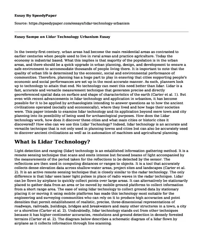
Light detection and ranging (lidar) technology is an established information gathering method. It is a remote sensing technique that scans and emits intense but focused beams of light accompanied by the measurements of the period taken for the reflections to be detected by the sensor. The reflections are then used in computing distances or ranges to objects. It is a tool that accurately collects dense elevation data across shallow-water areas, project sites and landscapes (Carter et al. 2). It is an active remote sensing technique that is closely similar to the radar technology. The only difference is that lidar uses laser light pulses in place of radio waves in the radar technique. Lidar can be flown by airplane to quickly collect points over large areas. It can alternatively be stationarily placed to gather data from an area or be moved by mobile ground platforms to collect information from a short range area. The ease of using lidar technology to collect ground data by stationary placing it or moving it using mobile platforms has made this technology most suitable for the engineering and surveying communities who can rely on it to produce high accuracies and point densities that permit establishment of realistic, precise, three-dimensional representations of roadways, railroads, buildings, bridges and breakwaters and many other structures in a town, a city or a shoreline (Carter et al. 2). Undoubtedly, lidar technology stands out from other techniques because it has higher centimeter accuracies, resolutions and ground detection in densely forested terrains (Carter et al. 2). The diagram below describes a schematic diagram of a lidar flown by airplane as it collects information through line scanning.
Figure 1: Schematic diagram of a lidar flown by airplane
Source: (Carter et al. 2).
Lidar Technology and Archeological Application
The establishment of the lidar technology has not only been the good news to surveyors and engineers but also archeologists. Archeologists can now easily trace ancient societies, how they lived, what they were doing and how they were organized. But how is lidar applied for archeological missions? To understand how archeologists apply lidar technology in their work, one first needs to understand how archeologists work towards discovering the history of earlier civilizations.
Archeologists are people attempting to understand the current societies by establishing their origins. They do so by examining the ways of lives and tools used by their ancestors. Unfortunately, archeologists have to undergo drudgeries to discover artifacts, remains and other crucial information that they can study to understand civilizations that existed for many years ago. Since these civilizations may have existed thousands of years ago, the artifacts and their remains may have been buried several feet underground as a result of erosion and deposition. The archeologists often have to guess where such information may exist and excavate the entire area to obtain information. According to the Society for American Archaeology, archeologists have been using various means to identify archeological sites including archeological predictive model, surface surveys, and shovel test pits. In the predictive model, archeologists rely on probability where it is guessed that probably an archeological site will occur in a given area. Their probability leads them to assess factors such as ground steepness, soil type and distance from water. They will often obtain a sample of the area and test it in the laboratory to detect any archeological information.
Surface surveys are conducted when a systematic examination of the land is required (Society for American Archeology). A team of archeologists is sent to the suspected area. They will then walk in straight lines back and forth until they cover the entire study area examining the existing artifacts, color changes, metals and pits that may exist. To aid their study, they will use tape measures and compasses to ensure that they are making examinations in straight lines and they will accurately measure the location where they have discovered archeological information.
Where archeologists fail to discover their data on the earth's surface, they are forced to undertake shovel test pits in which they make shallow pits within the area of a potential archeological site. The shallow pits are aimed at discovering covered artifacts and archeological materials such as metals or even bone remains of the ancient people. The soil may be taken to the lab and tested for any archeological evidence.
The above techniques used by archeologists to identify archeological sites and discover archeological evidence are tedious, time-consuming and environmentally destructive. They are also inaccurate and may fail to discover archeological information within the suspected area due to their guessing nature.
What magic does lidar technology introduce to archeologists so that they can eliminate the above weaknesses attuned to traditional archeological tools and techniques? Undoubtedly, lidar technology is a total revolution for the archeologists. Whether the archeological data is hidden in the forest or a wide vast inaccessible area, lidar technology can quickly unearth that information when flown by airplane across the area. This is so because lidar technology can speedily measure the earth's surface through sampling rates up to 150,000 pulses per second (Carter et al. 3). The outcome is a densely spaced network of an accurate;y georeferenced point cloud or elevation points. These elevation points are then used to generate three-dimensional representations of the studied area with all the surface information as well as the features. Important to note also is the fact that most lidar technologies operate in the near-infrared region of the electromagnetic spectrum giving it an ability to measure even seafloor elevations and allow for detection of archeological information that could be deposited under water. Infrared allows an archeologist to map the past and see it differently and process the information to detect the actual chemical change that has occurred as a result of building materials used by ancient civilizations (Parcak).
Moreover, lidar technology provides archeologists with elevations of high accuracy between 6 and 12 inches for ancient data and 4 to 8 inches for more recent data (Carter et al. 3). Another most important aspect of the lidar technology for archeologists is the ability to "see under trees" (Carter et al. 4). Ancient civilizations and cities may have occurred thousands of years ago and possibly hidden under thick forests. Lidar technology allows the archeologists to collect data from such points from the space through remote sensing ability of the lidar which can penetrate thick vegetation. The ability of the lidar to see through canopies and record both leaf and ground data allows for visualization of the features under the forest. Overall, lidar technology's accuracy is of the essence to archeologists in spotting the exact archeological sites that will provide detailed information on the earlier civilizations and cities.
An Example of a City and Historic Site Already Discovered Through Lidar Technology
Recently, lidar technology has allowed archeologists to discover new archeological sites that no one knew about them before. The temple-city of Angkor Wat located in central Cambodia is one such area with undiscovered archeological sites (Daley). The archeologists attached a lidar with laser scanning system on a helicopter skid and flew over the mounds of earth, walls, roads, foundations and other permanent structures which were not visible due to dense vegetation covering the entire Khmer area to detect archeological information on the Khmer legacy. The researchers surveyed 734 square miles of terrain for over 90 hours, and they were able to discover the temple complexes and entire population centers that had been covered by the vegetation (Daley). The information revealed a medieval city 60 miles east of Angkor near the Preah Khan of Kompong.
According to Horton, the researchers who discovered the hidden Angkor city did not only detect the monumental stone structures but were also able to unearth the ancient urban cultures that surrounded the temples and were identifiable by the remains of artifacts such as the roads, mounds, canals, and quarries. The achievements in the discovery were aided by the lidar's high accuracy of +/-150mm with about sixteen data points measured in every square meter. The cultural discovery in the new city allows for historians to demonstrate a novel view of the Khmer culture. The discovery also informs that even the thick rainforests that one cannot imagine of inhabiting were once homes for populations in the past.
Other Applications of the Lidar Technology
Apart from using lidar technology for archeological discovery of ancient cities and cultures, it may also be applied to many other areas. It is used autonomous world. In self-drive vehicles, lidar data is used as the eyes for the vehicle to guide it on the road. Lidar technology has also been used in agriculture fields. It is used to create three-dimensional elevation map of a particular piece of land. The map can then be used to generate the slope and sunlight exposure area map. Such a map is crucial for a farmer in identifying areas that require more water and fertilizer application. Elsewhere, lidar technology may be applied to study forests and trees to gather data for timber management. Just as the lidar data were used to uncover information under the forest cover by the archeologists, the technique can also be used to gather data on trees to help understand how much wood is present, when it is ready for harvesting and how much harvest to expect.
Cite this page
Essay Sampe on Lidar Technology Urbanism. (2022, Jun 01). Retrieved from https://speedypaper.net/essays/lidar-technology-urbanism
Request Removal
If you are the original author of this essay and no longer wish to have it published on the SpeedyPaper website, please click below to request its removal:
- Essay Example in Dentistry: Errors when Using Ultrasonic Inserts
- Free Essay on the Implementation of Information Technology Internal Controls
- Economic Foundation of the US Healthcare Delivery
- Essay Sample Answering on Why Are the US Citizens Rapidly Becoming More Obese
- Essay Sample: Role of Women in the Frankenstein
- Theory and Practice of Diplomacy - Essay Sample on Foreign Policy
- Free Essay - "The Ride of a Lifetime" by Robert Iger
Popular categories